THOUSANDS OF FREE BLOGGER TEMPLATES

Thursday, 7 January 2010

Railroad will extend to Delta? Train scare!

Today I read that Alaska Railroad got permission from the federal board to extend it's tracks to Delta Junction, 90 miles southeast of Fairbanks on the Richardson Highway. Even in Alaska, nature has to step aside for developtment, but it would be easier for people to get around if they don't want to drive such long distance. I never thought that railroad will extend farther than Eielson Air Force Base. Maybe in 15 years it will to to Valdez or Dawson, YT? It might take a year or two to build bridges and tracks, so it wouldn't happen suddenly. The noise of the train cutting through quiet hills of Salcha and Delta? Sounds weird, and invasive!

Friday, 15 August 2008

Chicken

Chicken is a census-designated place in the Southeast Fairbanks Census Area. Chicken is located at 64°4′15″N, 141°52′30″W (64.070738, -141.874894)[1].
According to the
United States Census Bureau, the CDP has a total area of 115.4 square miles (298.9 km²), all of it land. Elevation is 1677 feet.
The only transportation to Chicken is a small local
airstrip, as well as Alaska Route 5, the Taylor Highway. The highway is not maintained in winter.If you need to catch a plane,someone be happy to roll you on over to the airport inside a large tire.In order to find Downtown Chicken,travelers need to turn off the main road,go straight down Airport Road a few hundred yards and look to the right.
There is a
United States Post Office for Chicken.
There is no local
telephone exchange service in Chicken.

Thursday, 14 August 2008

Eagle

Eagle is a city located along the United States-Canada border in the Southeast Fairbanks Census Area, Alaska, United States. It includes Eagle Historic District, a U.S. National Historic Landmark.

Eagle is located at 64°47′10″N, 141°11′60″W (64.786022, -141.199917)[2].
Eagle is located 8 miles (13 km) west of the border between Alaska and the Yukon Territory of Canada on the Taylor Highway. It sits along the Yukon River. Elevation os 853 ft(260meters). ZIP code for the area is 99738.
According to the United States Census Bureau, the city has a total area of 1.0 square mile (2.6 km²), all land.

Tok

Tok is a census-designated place in the Southeast Fairbanks Census Area which is located on Milepost 1314 on the Alaska(Alcan) Highway. The elevation is 1,601 feet. ZIP code for the area is 99780.

Tok lies at an important junction along the Alaska Highway between the Tanana River and the Alaska Range.
According to the United States Census Bureau, the CDP has a total area of 132.3 square miles (342.6 km²), all of it land.

Delta Junction


The city is located a short distance south of the confluence of the Delta River with the Tanana River, which is at Big Delta. It is about 160 km (99 miles) south of Fairbanks on the Richardson Highway. Elevation is 1,158 ft. Delta Junction is the official end of the Alaska(Alcan) Highway.

Delta Junction is located at 64°2′52″N, 145°43′7″W (64.047669, -145.718655)[2].
According to the United States Census Bureau, the city has a total area of 17.3 square miles (44.7 km²), all of it land.

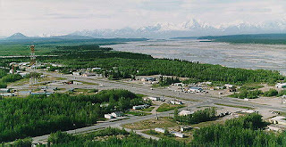
"Big Delta" lies at the intersection of the Delta River and the Tanana River. The City of Delta Junction sits on the Delta River at the intersection of the Richardson Highway and the famed Alaska Highway (actually, the end of the Alaska Highway). The city and Delta community lie within the fertile Tanana River valley. Three mountain ranges -- the White Mountains to the north, the Granite Mountains to the southeast, and the Alaska Range to the southwest -- and the Delta River to the west surround the town.
Once overlain by glaciers, the geology is marked by glacial moraines as well as alluvial deposits from the Delta and Tanana Rivers. Numerous mineral deposits are found in the vicinity of Delta Junction ranging from gold to molybdenum to coal. A prominent natural feature on the landscape is Donnelly Dome, located within the Donnelly Training Area of Fort Wainwright (formerly a part of nearby Fort Greely until 2001), to the south of Delta Junction. This dome was formed as a glacier coming from the Alaska Range split in two, carving away sides of a former mountain.
As it is not near the ocean, this area is drier than coastal Alaska and experiences seasonal extremes typical of subarctic areas. The annual precipitation is only 30.5 cm (12 inches), including 94 cm (37 inches) of snow. The average low temperature in January is -23°C (-11°F).The average high during July is +20°C (+69°F). Temperature extremes have been recorded from -53°C to +33°C (-63°F to +92°F).
Delta Junction is mostly sunny in the summer and split between clear and overcast days in the winter. On clear winter nights, the aurora borealis can often be seen dancing in the sky. Like all subarctic regions, the months from May to July in the summer have no night, only a twilight during the night hours. The months of November to January have 4 to 5 daylight and twilight hours.
Delta Junction was known as the "Windy City" and "Little Chicago" by many soldiers on Fort Greely, a reference to Chicago in the lower 48 United States. In Delta Junction itself, but not in the nearby areas, wind blows many days from the south up the Delta River from the Gulf of Alaska, bringing river silt in the summer and snowdrifts in the winter. There are usually several days in the winter when the temperature is in the range of -40° (C or F) when a wind (known as a Chinook wind) begins to blow. A few minutes later, the temperature climbs to above 0°C (+32°F). When the wind stops, the temperature returns to its colder value.

Moose Creek

Moose Creek is located about 17 miles south of Fairbanks, Alaska along the Richardson Highway. Moose Creek is bordered by Eielson Air Force Base to the south, the Tanana River to the west, and the Chena River Flood Control Project to the north.
Moose Creek is located at 64°42′45″N, 147°9′40″W (64.712474, -147.161128)[1].
According to the United States Census Bureau, the CDP has a total area of 1.7 square miles (4.4 km²), of which, 1.6 square miles (4.1 km²) of it is land and 0.1 square miles (0.3 km²) of it (6.51%) is water. It is located beside the Moose Creek Bluff, which is a medium size hill with a rocky cliff facing the Richardson Highway.
Moose Creek,AK gets 13 inches of rain per year. On average, there are 154 sunny days per year. The January low is -18. The temperature is pretty much like in Fairbanks and North Pole,Ak.

Big Delta

Big Delta is located 8 miles north of Delta Junction on the Richardson Highway. Big Delta is at the confluence of the Delta River and the Tanana River and gets it name from the huge river delta formed by the confluence.
Big Delta is located at 64°8′50″N, 145°48′6″W (64.147324, -145.801545)[1].
According to the United States Census Bureau, the CDP has a total area of 61.1 square miles (158.3 km²), of which, 55.2 square miles (143.0 km²) of it is land and 5.9 square miles (15.4 km²) of it (9.70%) is water.